INTRODUCTION
In India instrumental monitoring of earthquakes started in 1898 with the installation of the first seismograph of the country at Alipore (Calcutta) by India Meteorological Department (IMD). Till 1930s, there were only four seismological observatories in operation at Calcutta, Bombay, Kodaikanal and Agra. However, these were supplemented by the observatories at Dehra Dun, Colombo and later at Hyderabad with the co-operation of Surveyor General of India, the Superintendent of Colombo Observatory and the Director of Nizamia Observatory respectively.
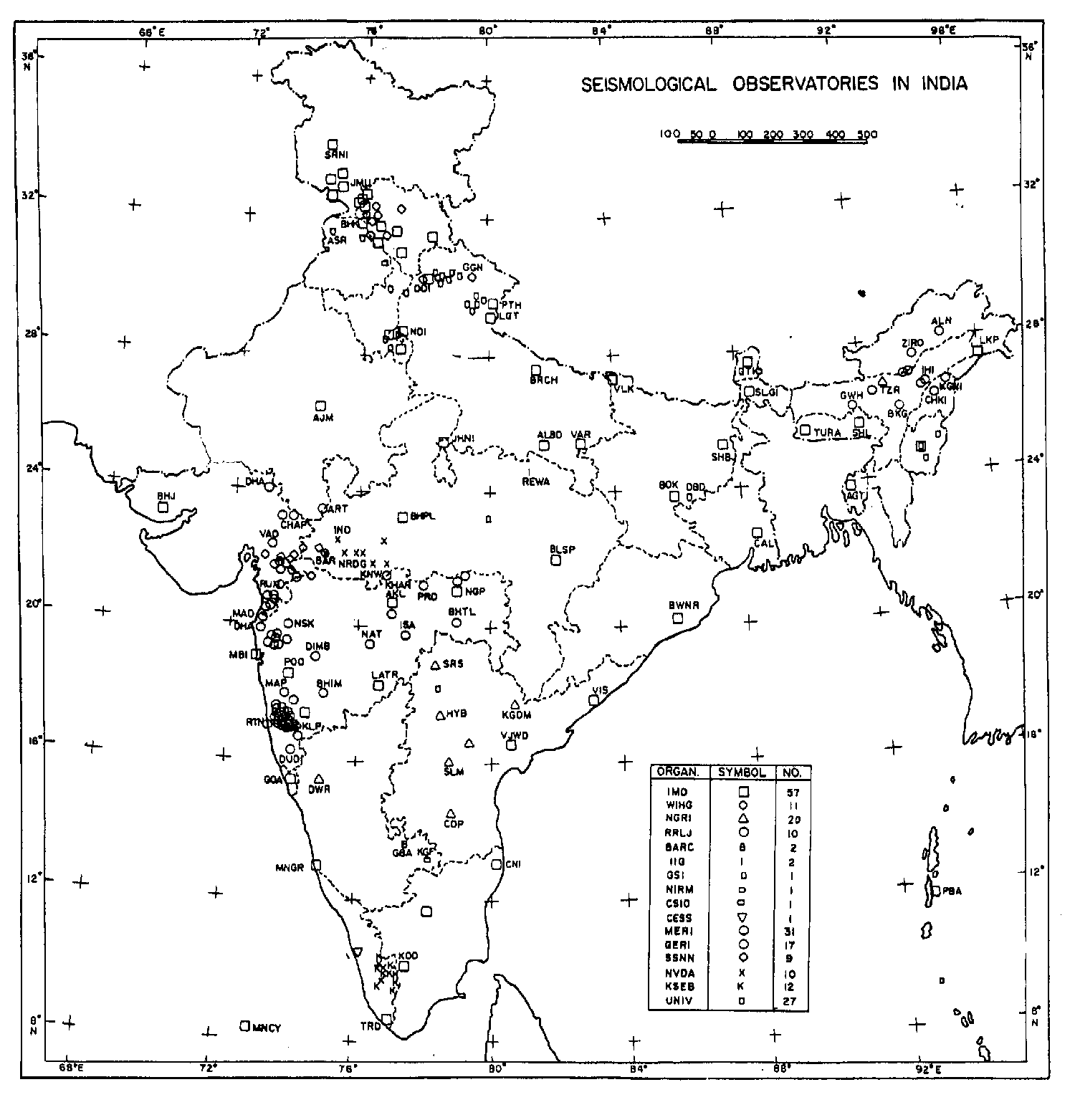
By the year 1970, IMD seismological network had grown to comprise 18 permanent observatories under national network and 12 observatories in North India for studying seismicity around river valley projects and Delhi region. During 1963-64, the observatories at Shillong, New Delhi, Poona and Kodaikanal were upgraded to conform to WorldWide Standardized Seismological Network (WWSSN) standards under USGS collaboration. During 1965, Bhabha Atomic Research Centre (BARC) established a seismic array station at Gauribidanur near Bangalore. In India, at present there are 212 seismological observatories run by various Central and State Government organizations, research institutions and Universities (Figure 1). Digital seismographs at many of these observatories are steadily replacing the analogue seismographs.
The conventional approach of analyzing the seismograms, produced by analog seismographs was mostly confined to identification of various phases, in an attempt to locate the hypocentral parameters. With the advent of computer-aided digital recording systems, the seismic data analysis became possible not only in time domain but also in frequency domain so that more detailed information about earthquake source and Earth’s interior can be inferred. In the present talk we describe the recent advances in seismic instrumentation as well as approaches to near real time monitoring.
EARTHQUAKES IN INDIA
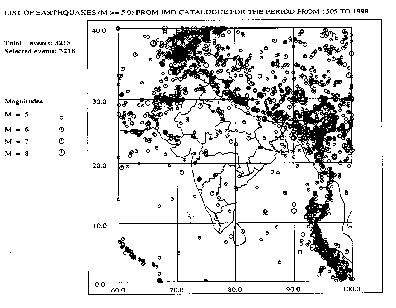
India has witnessed many devastating earthquakes of the world. Figure 2 shows the epicentral map of India for earthquakes of magnitude 5 and aboce from historical times. A list of damaging earthquakes in and around India is given in Table 1. Geographically the seismic activity can be divided into three regions: (a) Himalaya, (b) Andaman-Nicobar islands and (c) Peninsular India.
a) Himalaya
The seismicity in Himalaya is explained due to continued collision of Indian and Eurasian plates which also gave birth to gigantic Himalayan Mountains. Two major thrusts identified are MCT and MBT. The Himalaya and its vicinity have been the sites of great earthquakes in this country. Some of the very large and most destructive earthquakes during past 200 years are : Kashmir, 1828; Kashmir, 1885; Nepal., 1833; Myanmar, 1839; Shillong plateau, 1897; Kangra, 1905; Bihar-Nepal, 1934; Arunachal Pradesh 1950. Significant earthquakes (maximum MM intensity VII or more) since 1980 are : UP hills-Nepal, 1980; Jammu, 1980; Sikkim, 1980’ Cachar, 1984; Dharamsala, 1986; Bangladesh-NE India, 1988; Uttarkashi 1991 and Chamoli 1999.
b) Andaman and Nicobar islands
The Andaman Nicobar islands region is one of the most seismically active regions in the Bay of Bengal. There were several damaging earthquakes in this region. In 1881 an earthquake of very severe intensity occurred in Bay of Bengal causing maximum damage to Port Blair. Another great earthquake occurred on June 26, 1941. During recent times, in 1982 southern Nicobar witnessed and earthquake with maximum MM intensity VII.
c) Indian Peninsula
In this part of India the recurrence time of occurrence of an earthquake is long and magnitudes normally remained low compared to the above two regions. However exception is the earthquake of 1819 at Kutch with magnitude 8 and maximum intensity XI. During last 200 years, there are several earthquakes with maximum MM intensity VII or more. These are : Malabar coast 1828, Bellary 1843, Narmada 1846, Mt Abu 1848, Surat 1863, Coimbatore 1900, Bhavnagar 1919, Anjar 1956 and Koyna 1967. Similar earthquakes in recent times are Latur 1993, Jabalpur 1997.
SEISMOLOGICAL OBSERVATORIES
At present IMD operates and maintains the national seismological network consisting of 45 observatories spread over the length and breadth of the country. 12 more observatories are working in North India for special studies. In addition, 155 seismological observatories are run in India by other R & D institutions (45 observatories), River Valley Project authorities (79 observatories) and Universities (27 observatories). There is a plan to integrate some of these observatories in the national network.
Till 1970, these observatories were equipped with photographic recording seismographs such as Milne-Shaw, Wood-Anderson and electromagnetic seismographs. However, during seventies many of these observatories were upgraded with visible seismographs. A Seismic Research Observatory (SRO) system with a broadband borehole seismometer and a digital data recording system was installed at Central Seismological Observatory (CSO), Shillong, in 1978. The India Meteorological Department started operation of five stand-alone digital seismographs during early nineties. The seismological observatory at National Geophysical Research Institute, Hyderabad equipped with WWSSN type analogue seismograph system was upgraded during early nineties with a very broadband seismograph in collaboration with French world wide network GEOSCOPE.
During 1996-97, ten seismological observatories of IMD in the Peninsular India had been upgraded with digital broadband seismographs (bandwidth upto 120 sec) and digital accelerographs to the standards of Global Seismograph Network (GSN). During 1999-2000, fourteen more observatories of IMD have been upgraded with another type of digital broadband seismographs (bandwidth upto 30 sec). At the same period, similar seismographs have also been installed at ten new observatories in the Peninsular India by a few R & D institutions. Another landmark development in the new millennium in seismic instrumentation is a 16-element VSAT based seismic telemetry system being deployed in and around Delhi by IMD.
NATIONAL SEISMOLOGICAL DATABASE CENTRE
A National Seismological Database Centre (NSDC) has been set up at IMD, New Delhi; the computer system alongwith necessary software like SEISAN has been installed for analysis and archival of data. The digital data acquisition systems of GSN standard observatories are connected to the computer system of NSDC. To monitor and evaluate hypocentral parameters of earthquakes round the clock, NSDC pools through networking software SEISNET every half an hour through dial up modem, the information pertaining to detected event triggers from each of the ten GSN standard observatories. On identification of a trigger attributable to an event, the operator at NSDC decides to download the waveform data of desired stations using dial up modem and processes the data for evaluation of hypocentral parameters. A few observatories having a round the clock manpower for monitoring earthquake activity and equipped with visible recording seismographs also transmit the data to NSDC immediately after the occurrence of a significant earthquake. The parameters of all significant earthquakes occurring in India and its neighborhood are evaluated and are disseminated to concerned Government authorities and media. Such information helps to build confidence among people and helps in relief work, if necessary. The information is also made available in IMD website: http://www.imd.ernet.in. The hypocentral parameters thus obtained in operational mode are improved later by incorporating data from other observatories of IMD and a seismological bulletin for each month is published.
CONCLUSIONS
Keeping pace with the technological developments, the seismic instrumentation and data interpretation in India have grown by leaps and bounds over the years. Since 1997, 24 seismological observatories under the national network of IMD have been upgraded with state-of-the-art digital seismograph systems having broad frequency response, large dynamic range and accurate time keeping using GPS synchronization. The data generated at some of these observatories of IMD is presently available in near real time at NSDC, IMD, New Delhi. Also, a number of new observatories have been set up with similar systems by various State and Central Government agencies. These digital broadband systems have generated very useful, high-resolution data sets for several significant earthquakes including Jabalpur [1997] and Chamoli [1999]. This has greatly improved not only the hypocentral location capabilities in operational mode but also the estimation of detailed source parameters, crust and upper mantle structure, etc. in research mode.
For further reading
Bhattacharya, SN; Dattatrayam, RS (2000). Recent advances in seismic instrumentation and data interpretation in India. Current Science, 79(9): November 10.
* This paper was presented in the "International Workshop on Geoenvironmental Hazards and the Brain Storming Session on Arsenic Problem" held at SES, JNU, New Delhi during Nov. 29 - Dec.1st 2000. - two months before the Gujarat Earthquake of Jan 26, 2001.
Table 1 List of some damaging earthquakes in India.
|
Date |
Epicentre Lat(0N) Long(0E) |
Location |
Magnitude |
|
1819 Jun 16 |
23.6 68.6 |
Kutch (Gujrat) |
8.0 |
|
1869 Jan 10 |
25 93 |
Near Cachar , Assam |
7.5 |
|
1885 May 30 |
34.1 74.6 |
Sopor, J &K |
7.0 |
|
1897 Jun 12 |
25.9 91.0 |
Shillong Plateau |
8.7 |
|
1905 Apr 04 |
32.3 76.3 |
Kangra, HP |
8.0 |
|
1918 Jul 08 |
24.5 91.0 |
Srimangal, Assam |
7.6 |
|
1930 Jul 02 |
25.8 90.2 |
Dhubri, Assam |
7.1 |
|
1934 Jan 15 |
26.6 86.8 |
Bihar-Nepal Border |
8.3 |
|
1941 Jun 26 |
12.4 92.5 |
Andaman islands |
8.1 |
|
1943 Oct 23 |
26.8 94.0 |
Assam |
7.2 |
|
1950 Aug 15 |
28.5 96.7 |
Arunachal-China border |
8.5 |
|
1956 Jul 21 |
23.3 70.0 |
Anjar, Gujrat |
7.0 |
|
1967 Dec 10 |
17.37 73.75 |
Koyna, Maharashtra |
6.5 |
|
1975 Jan 19 |
32.38 78.49 |
Kinnaur, HP |
6.2 |
|
1988 Aug 06 |
25.13 95.15 |
Manipur-Mayanmar border |
6.6 |
|
1988 Aug 21 |
26.72 86.63 |
Bihar-Nepal border |
6.4 |
|
1991 Oct 20 |
30.75 78.86 |
Uttarkashi, UP hills |
6.6 |
|
1993 Sep 30 |
18.07 76.62 |
Latur-Osmanabad, Maharashtra |
6.3 |
|
1997 May 22 |
23.08 80.06 |
Jabalpur, MP |
6.0 |
|
1999 Mar 29 |
30.41 79.42 |
Chamoli District, UP hills |
6.8 |